18 Must-Try Hikes in Southern Spain: From Easy Walks to Mountain Trails
Top 18 Hikes in Southern Spain: Easy to Challenging Trails,
Discover the 18 must-try hikes in Southern Spain, from easy coastal walks to thrilling mountain trails. Explore Andalucia’s diverse landscapes, stunning views, and unique natural wonders.
Top 18 Hikes in Southern Spain: Must-Try Trails,
Explore the best hiking trails in Southern Spain, from easy coastal walks to thrilling mountain paths. Discover Andalucia’s diverse landscapes and stunning natural wonders.
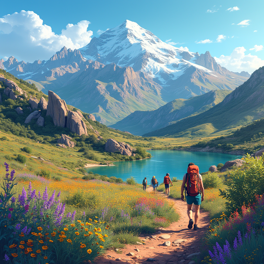
 Southern Spain’s hiking trails showcase a diversity that you won’t find anywhere else. The landscapes of Andalucia have taken my breath away countless times with their coastal paths, river canyons, and rugged peaks that reach beyond 3000 meters.
This region’s natural wonders will amaze you at every step. My adventures have led me through the thrilling Caminito del Rey, where paths cling to gorge walls 100 meters high. I’ve reached the summit of Mulhacen, Spain’s highest mainland peak at 3479 meters. The Rio Chillar’s refreshing water holes and narrow slot canyons make perfect summer hiking spots. Andalucia’s hiking experience stands out because national and natural parks protect almost one-third of its territory.
The region caters to every hiking enthusiast. You can challenge yourself with a 7-9 hour trek to Siete Lagunas that climbs 1500 meters, or watch magnificent griffon vultures with their 2.5-meter wingspans at Garganta Verde. The best time to plan your adventure is during April, May, June, September, or October when the weather is perfect. These 18 incredible trails will show you Southern Spain’s breathtaking beauty.
El Caminito del Rey, Malaga
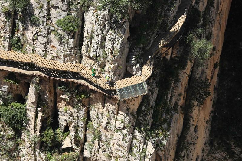
Image Source: Plataforma Oficial de reservas Caminito del Rey
El Caminito del Rey stands as one of Southern Spain’s best hikes today, though it started as a simple workman’s path. This amazing trail hugs the steep walls of the Gaitanes Gorge near Ardales. Visitors can enjoy breathtaking views from boardwalks that hang 100 meters above the Guadalhorce River.
El Caminito del Rey expresses
The path’s rich history began in 1901-1905 when Sociedad Hydroelectrica del Chorro built it to connect two hydroelectric sites. The trail got its royal name after King Alfonso XIII came to open the nearby dam in 1921. The path went through major renovations and reopened in 2015 after years of decay and several tragic accidents.
The complete experience stretches 7.7 kilometers and takes about 3-4 hours. My time on the renovated path showed these striking features:
- A spectacular aerial route with hanging bridges over deep gorges
- Views of the “fossil beach” with Jurassic-period remains
- A thrilling glass balcony that juts from the walkway
- The unforgettable suspension bridge that spans the canyon
El Caminito del Rey difficulty
The path might look scary, but today’s Caminito del Rey rates as a medium-low difficulty hike. A linear, one-way route runs downward from north to south, making it available to more people. But some limits apply:
The trail bars children under 8 years old. The path doesn’t suit people with severe vertigo, heart conditions, or mobility issues. You must wear proper footwear – staff check for closed, comfortable shoes with good grip at the control cabin.
El Caminito del Rey ticket information
Book your tickets ahead through the official website or at the north entrance office. You can choose between two options:
General admission: €10 to explore on your own Guided tour: €18 with a certified guide in groups up to 30 people
Tickets sell out fast as they release them in batches throughout the year. Staff give you a helmet at the control cabin that you return after finishing.
Think over adding a shuttle bus ticket (€2.50) since the trail ends at a different spot from where it starts. This helps you get back to your starting point easily.
Rio Chillar, Malaga
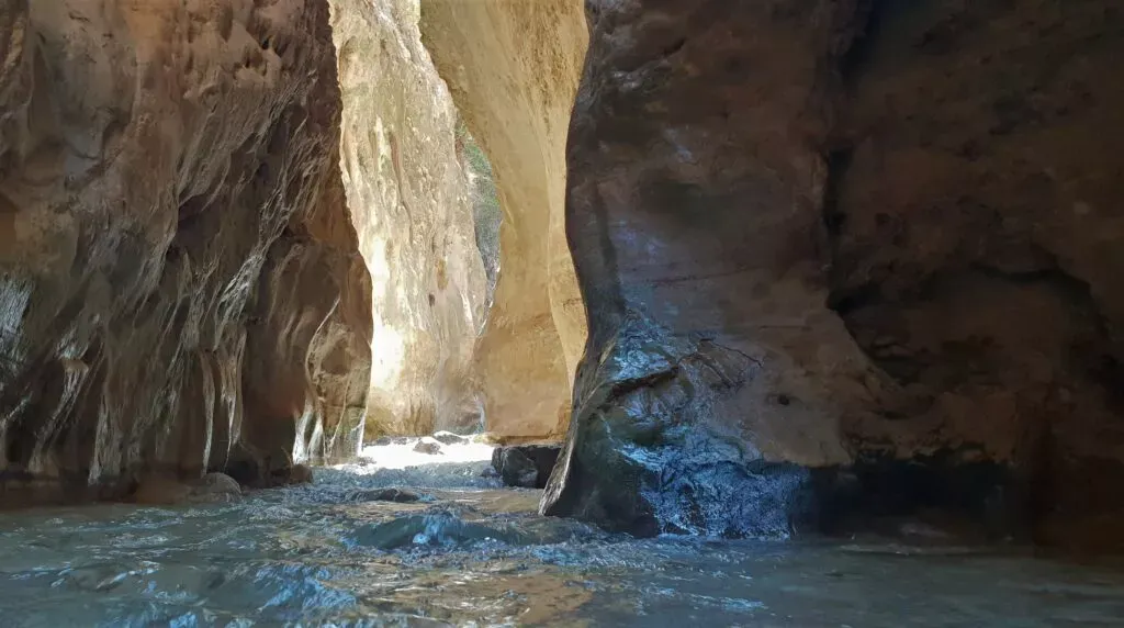
Image Source: Andaluciamia
The Rio Chillar hike near Nerja stands out as one of the most refreshing trails among the best hikes in Southern Spain. You’ll walk through flowing water for miles. The unique water adventure guides you through marble gorges, natural pools, and beautiful waterfalls within the protected Tejeda, Almijara, and Alhama Nature Reserve.
Rio Chillar trail experience
The Rio Chillar route has two natural sections. The original part begins with a 30-minute walk near the river before stepping into the water. This section is easy and great for families with children. The path gets narrower as you move into spectacular marble gorges called “Los Cahorros,” where sunlight creates stunning color patterns on the nearby cliffs.
A beautiful natural pool perfect to cool off appears after about 1.5 hours. Adventure seekers can continue another 1.5 hours to reach the main waterfall. The waterfall’s surroundings feature natural pools that look like a picturesque oasis. The complete trek covers about 16 kilometers and takes 5-7 hours round trip.
Rio Chillar best time to visit
The summer months (May to October) are ideal since the cool water helps beat the Spanish heat. Notwithstanding that, August gets too crowded. Weekends are best experienced early in the morning for a peaceful hike.
Autumn and spring (September to December and March to June) offer milder weather that suits the entire trail better. The water levels can rise faster during or after rainy days, making the experience potentially dangerous.
Rio Chillar safety tips
The right footwear makes all the difference since you’ll walk on wet, slippery stones. Sport sneakers or hiking shoes that can get wet work best – not flip-flops or heavy mountain boots that become a burden when wet. Thick hiking socks help prevent abrasions from wet shoes.
Pack enough water, food, sunscreen, and a hat for several hours under the sun. A waterproof bag protects valuables like phones and cameras. The river is available without permits, but authorities have introduced conservation protocols. Plans exist to implement controlled access (maximum 500 people daily) to protect this fragile ecosystem.
Ruta del Gollizno, Granada
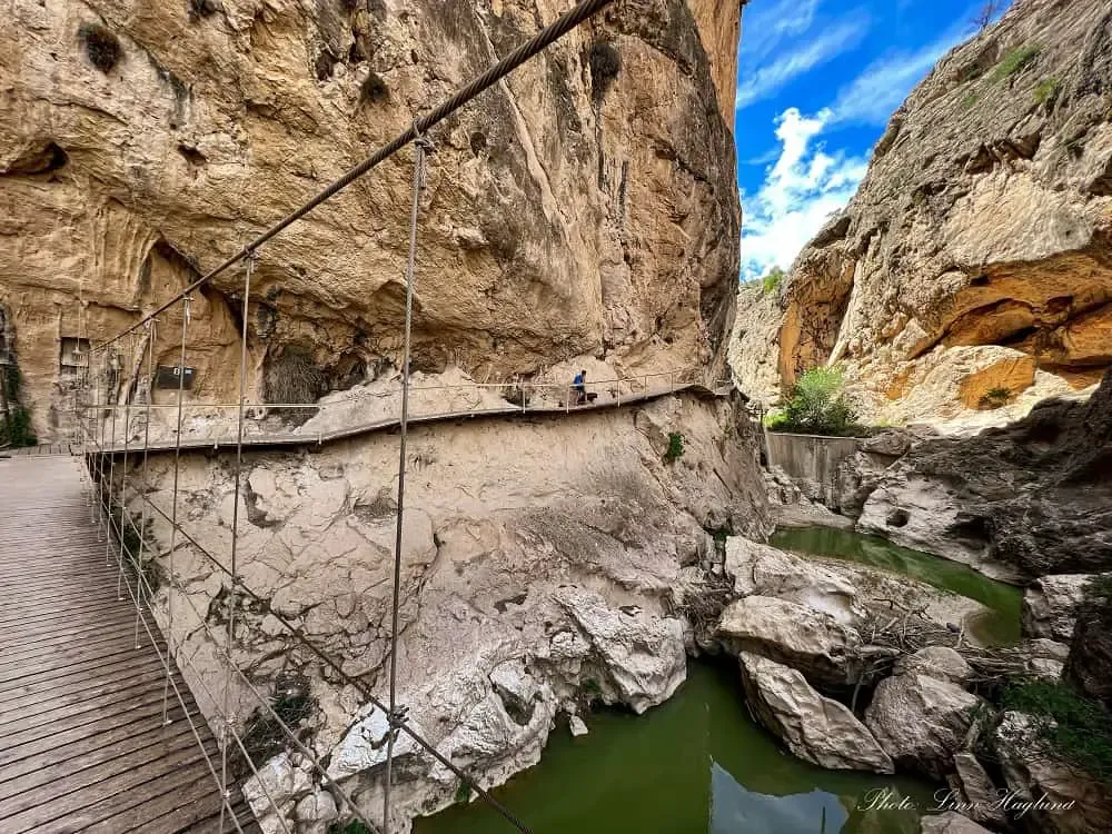
Image Source: Andalucia Hiking
Ruta del Gollizno ranks among Southern Spain’s most amazing yet lesser-known hikes, tucked away in Granada province’s rugged terrain. This stunning 8-10.5 km circular route takes you through a dramatic river gorge and lets you walk across a suspension bridge. The paths cling to cliff walls, giving you an experience like a mini Caminito del Rey but with nowhere near as many people.
Ruta del Gollizno scenic views
The trail weaves through the deep Tajos de la Hoz gorge with towering walls rising on both sides, revealing breathtaking views. You’ll come across several visual treats along the way:
- A bouncing suspension bridge that crosses the river toward a huge cave opening
- Paths that cling to the gorge walls and give you thrilling views
- Lookout points where you can see Moclín’s 13th-century Arab fortress
- The charming Ermita de las Angustias chapel that sits on the path’s edge
Nature’s beauty matches these human-made wonders. Many hikers spot wild mountain goats on the rocky cliffs—a sight worth capturing with your zoom lens.
Ruta del Gollizno hiking tips
The best time to hike is between mid-September and mid-June since summer can get too hot, especially if the river dries up. April and May shine as perfect months with spring flowers dotting the landscape. Wildlife watching is best in the early morning, and you’ll dodge weekend crowds too.
You can start your loop from either Moclín or Olivares villages and end up where you began. Remember to pack:
- Lots of water, especially in warm weather
- Sturdy hiking shoes with good grip
- A hat and sunscreen
- Food to enjoy at the picnic spots
Ruta del Gollizno difficulty level
The trail sits at moderate difficulty, but some parts need decent fitness. You’ll climb about 405 meters in total with some steep ups and downs. Most people finish in 3-4 hours, though some zip through in 1.5-2 hours at a quick pace.
The path changes from forest trails to rocky sections and throws in some tough uphill climbs, especially on the way back to Moclín. First-timers should take their time to enjoy the views and natural features that make this one of Granada’s best hikes.
Mulhacén, Granada
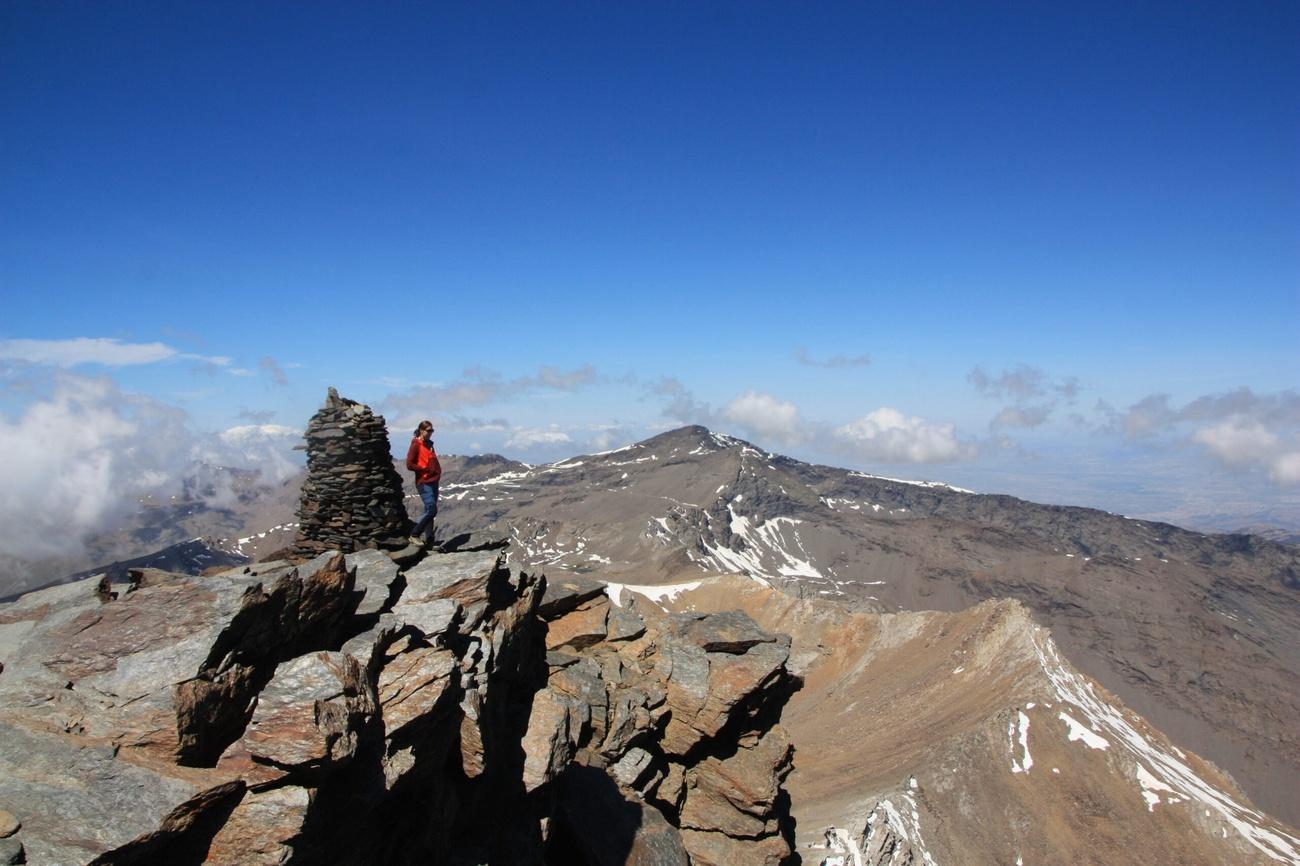
Image Source: Sierra y Sol
Mulhacén stands proudly at 3,479 meters as mainland Spain’s highest peak. The mountain ranks as Western Europe’s third most prominent summit after Mont Blanc and Mount Etna. This magnificent peak in Granada’s Sierra Nevada gives hikers some of the most rewarding experiences in Southern Spain. The views of the Mediterranean are spectacular on clear days.
Mulhacén hiking routes
Hikers can choose from several trails based on their experience:
- South Route: This path is the most available option that suits beginners and intermediate hikers. The trail has gentle slopes and well-kept paths.
- West Route: A more demanding trail that needs better fitness. The path has steeper sections and rock scrambling – perfect for adventure seekers who love rugged landscapes.
- North Route: The toughest choice that only experienced hikers should attempt. The trail comes with steep climbs, rocky terrain, and possible dangers.
Many hikers also love traditional routes. The path from Alto Chorrillo takes 6 hours along the beautiful west ridge. Another option is the challenging 21 km climb through Cañada de Siete Lagunas from Trevélez. The classic route from Refugio Poqueira remains popular too.
Mulhacén best season
Summer months from June to September are the best time to climb Mulhacén. Hikers can enjoy clear skies, pleasant temperatures, and little rain during this period. Early September is perfect for those who want great conditions with fewer people around.
The routes become technically challenging outside these months. Snow and ice make paths hard to access without winter gear. Hikers planning trips in spring and autumn should check the conditions carefully.
Mulhacén permit and transport info
The permit situation is a bit unclear. Some sources say you need permits for certain protected areas, while others say you don’t. The best approach is to check current rules before your trip.
You can get there by:
- Taking the National Park bus service (€13) from Capileira to Mirador de Trevelez at 2,700 meters – this runs in summer only
- Driving your car to Hoya del Portillo (2,145 meters), the highest point cars can reach
Hikers can stay at mountain refuges like Refugio Poqueira (2,500m), Albergue Universitario (2,550m), or Refugio de Caldera (3,050m). You can also camp in the wild if you let park authorities know beforehand.
Pico Veleta, Granada
Image Source: Andalucia Hiking
Pico Veleta rises 3,398 meters as Spain’s third-highest mainland peak and Sierra Nevada’s second-highest summit. This stunning mountain peak is a chance to experience high-altitude hiking that’s easily available among Southern Spain’s best trails. The views are exceptional – you can see all the way to Africa when the sky is clear.
Pico Veleta trail overview
The hiking path starts at Hoya de la Mora (2,500m) with a moderate 9-kilometer round-trip climb. Most hikers take about 3 hours to reach the top and 2 hours to come down. The trail has a manageable slope that makes it perfect for beginners who want to try high mountain hiking.
Your trip takes you past several landmarks. You’ll see the altar of Virgen de las Nieves first, then pass the ski resort fork at Borreguiles. The last stretch is the steepest, but the summit rewards you with breathtaking 360° views. You can see Sierra Nevada, Granada city, the Mediterranean, and sometimes even the African coastline.
Pico Veleta accessibility
This mountain peak is much easier to reach than most high summits. You can drive from Granada to Hoya de la Mora in about 50 minutes. On top of that, a bus runs from Granada to the trailhead during hiking season from May to November.
The mountain has an asphalt road that goes almost to the top. Regular traffic can’t use it, but authorized National Park microbuses run from Hoya de la Mora to Posiciones del Veleta. Ski lifts work as summer transport in July and August. They take visitors up to 3,200 meters, so even non-hikers can get close to the peak.
Pico Veleta hiking tips
The altitude means you should always pack a jacket or fleece whatever the season – the temperature can drop at 3,500 meters even in summer. You just need water and snacks to keep your energy up. Anyone with decent fitness can try this climb without much preparation.
Summer offers the best conditions, which makes this peak unique among high mountains because it’s available throughout the season. Winter climbing should be avoided completely since storms can appear quickly. Spring brings its own challenges – melting snow creates dangerous ice patches that need special equipment.
Siete Lagunas, Granada
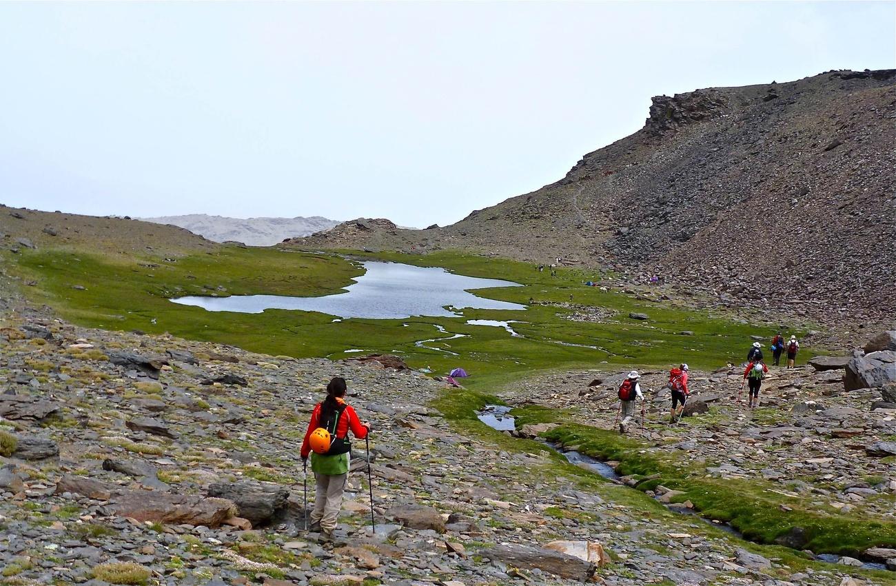
Image Source: Sierra y Sol
The stunning glacial valley of Siete Lagunas sits between the mighty peaks of Mulhacén and Alcazaba in Sierra Nevada. This mountain paradise with its seven scattered lakes gives hikers one of the toughest but most rewarding experiences in southern Spain. The steep climb reaches 3,000 meters above sea level.
Siete Lagunas trail description
The tough path to Siete Lagunas starts in Trevélez village. It’s a 17.5-kilometer round trip that climbs almost 1500 meters. Most hikers take 7-9 hours to complete this physically demanding route. The trail begins on a paved road to Piedra Redonda, where you’ll see amazing views of the Trevélez River valley.
The path then winds through pine forests before reaching an unguarded shelter about 2.5-3 hours into the hike. Watch out for pine processionary caterpillars in spring if you’re hiking with dogs. The last part is a steep scramble next to the impressive Chorreras Negras waterfall. This leads to Laguna Hondera, the biggest and lowest of the seven lakes.
The view from the top makes it all worthwhile. Green meadows (Borreguiles) stretch out beneath rocky mountain walls. You can spot unique high-altitude plants like snow stars and gentians. Mountain goats often come down to the lakes to graze when evening falls.
Siete Lagunas camping options
You’ll need permission from Sierra Nevada National Park authorities to camp overnight in Siete Lagunas. Most people set up camp near Laguna Hondera, usually by the caves and waterfall where the ground stays drier. The high altitude means nights are very cold, even in summer, and temperatures often drop below freezing.
Essential camping gear includes:
- Tent and sleeping pad
- Warm sleeping bag (suitable for below-freezing temperatures)
- Thermal clothing and extra layers
- Cooking equipment and lightweight food
- Water purifier as natural sources are available
Siete Lagunas best time to hike
The best months to hike Siete Lagunas are June through October. Late May and June are perfect times to visit. Melting snow creates powerful waterfalls and fills all seven lagoons. The smaller lakes usually dry up as summer moves on.
Snow and ice make the final waterfall climb dangerous before mid-May, so you’ll need special equipment. The weather changes quickly at this height, so always check the forecast before you start. Rain becomes more common in the last three months of the year, making rocky sections slippery and risky.
Take extra time to explore beyond the main lake if this is your first visit. The other six lagoons hide behind Laguna Hondera and show off even more amazing views of this unique alpine landscape in Andalucia’s heart.
La Concha, Malaga
Image Source: Swish Marbella
La Concha mountain rises majestically from Marbella’s coastline, reaching 1,215 meters into the sky like a giant shell watching over the Costa del Sol. Local residents lovingly call it “the queen and protector of Marbella.” This iconic peak gives hikers one of Southern Spain’s best day hikes, with coastal views that attract adventure seekers throughout the year.
La Concha panoramic views
The summit gives determined hikers amazing 360-degree views that make every step worth the effort. Clear days reveal the Mediterranean coastline from Málaga to Gibraltar, and you can see Morocco’s mountains across the strait. The ridge path to the top offers stunning views of Marbella that create perfect photo spots. The Sierra Blanca range looks spectacular in the soft light of sunrise or sunset. Photographers love these moments when warm colors paint the landscape.
La Concha trail difficulty
The round trip usually takes 4-6 hours and covers about 14 kilometers with a tough climb of 750 meters. While the trail starts gently, it gets harder as you go up, with steep parts and rough ground that you’ll need to navigate carefully. You’ll find loose rocks in many places and spots where your hands help keep balance. The summit area has chains to help hikers through exposed sections that might worry anyone afraid of heights. La Concha sits firmly in the medium-hard category and isn’t right for beginners or kids.
La Concha hiking essentials
You just need these basics to hike safely and comfortably:
- Take 2-3 liters of water per person since the trail has no water sources
- Use sturdy hiking boots that support your ankles and grip well on rocks
- Pack extra layers whatever the season—the summit can be 8-11°C cooler than the coast
- Bring trekking poles to help with steep descents that can be tough on your knees
- Begin your hike early, ideally at sunrise, to avoid the hot sun and have enough daylight to return
The best time to hike runs from mid-September through May. Summer heat makes this exposed trail dangerous and uncomfortable. Local hiking companies offer guided tours if you want some help.
El Saltillo, Malaga
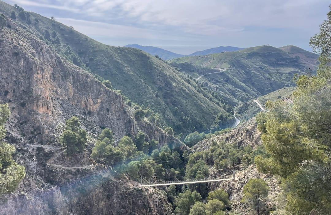
Image Source: AllTrails
The El Saltillo trail stands as one of Andalucia’s most exciting hiking experiences, nicknamed the “Caminito del Rey of Axarquía.” This amazing route connects Canillas de Aceituno and Sedella. A stunning suspension bridge crosses the Almanchares River gorge, making it a perfect spot for thrill-seeking hikers in Southern Spain.
El Saltillo hanging bridge
The trail’s crown jewel spans the dramatic Almanchares River gorge – a spectacular suspension bridge stretching 54 meters and hovering 70 meters above the riverbed. Since its opening in 2020, this impressive structure ranks among Spain’s three largest suspension bridges in protected natural areas. The bridge gently sways beneath your feet as you cross it. This creates an unforgettable heart-pounding moment that boosts your sense of adventure. The bridge is completely safe and the staff has managed to keep it well-maintained.
El Saltillo trail features
The 8-kilometer route showcases dramatic cliffs and deep ravines with breathtaking views. You’ll walk through olive groves and pine forests next to steep drops that show off the Sierra Tejeda mountains’ rugged beauty. La Maroma peak serves as a stunning backdrop for most of your trip. Metal walkways pinned to vertical cliff walls add more excitement beyond the main suspension bridge. This path is part of stage seven of the Gran Senda de Málaga that links Canillas de Aceituno with Cómpeta.
El Saltillo safety precautions
This trail isn’t suited for everyone. People who suffer from vertigo should skip this hike since many sections expose you to steep drops without barriers. Inexperienced hikers or children might find the technical challenges too difficult. You’ll need:
- Sturdy hiking boots with excellent grip
- Plenty of water (crucial during hot months)
- Walking poles to balance on steep sections
- Sun protection (the route offers limited shade)
The steep climb back from the bridge requires good fitness, and narrow paths demand careful steps. Check weather conditions before you start – wet surfaces become dangerously slippery.
Rio Borosa, Jaen
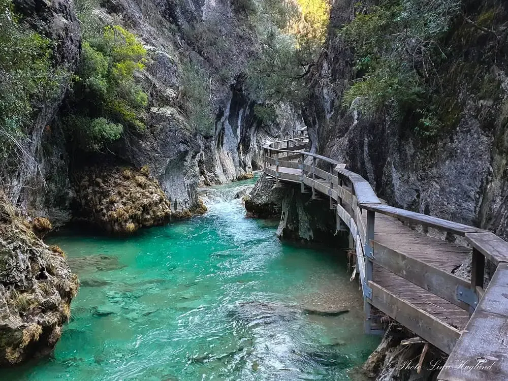
Image Source: Andalucia Hiking
Rio Borosa, a stunning trail in Cazorla, Segura y las Villas Natural Park of Jaén province, follows a crystal-clear river through spectacular gorges and dense forests. The trail’s unique blend of wooden boardwalks, turquoise pools, and dramatic mountain tunnels makes it one of Southern Spain’s best hikes.
Rio Borosa waterfalls
The river’s cascades create a magical water wonderland along the path. Small waterfalls and streams sparkle beside the trail during the first few kilometers. The path reveals more spectacular cascades past the hydroelectric station as it climbs upward. Cascada de la Calavera marks the last waterfall before the trail’s steep climb toward the mountain tunnels. The magnificent Salto de los Órganos waterfall greets hikers at the Embalse de Los Órganos reservoir. Many visitors describe it as “a little piece of Thailand carved into the mountains of Jaen.”
Rio Borosa trail length
The complete Rio Borosa hike covers 25 kilometers round-trip with 650 meters of elevation gain. Most hikers take 8-9 hours to finish the full trail. The path gives options to those with limited time or energy. Many families enjoy a shorter 7-kilometer round trip to Cerrada de Elías, just 3.5 kilometers in. Another option extends to the hydroelectric station before the trail becomes steeper and rockier.
Rio Borosa family-friendly tips
The trail ranks among Andalucia’s most family-friendly natural adventures:
- A broad dirt track makes the first section stroller-friendly
- Crystal-clear pools provide safe swimming spots along the river
- Kids love crossing the river’s wooden footbridges
- Shorter segments work well for young hikers who can turn back anytime
- Bring a torch when exploring the tunnels section with children
Spring through autumn offers the best family experience. Dogs should stay home from late December through early summer because of processionary caterpillars.
Pico Gilillo, Jaen
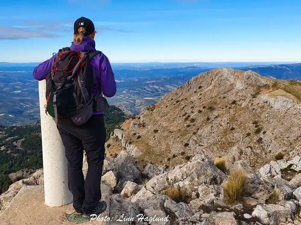
Image Source: Andalucia Hiking